| City/Town: • Hardesty |
| Location Class: • Government |
| Built: • 1978 | Abandoned: • 2010 |
| Status: • Abandoned |
| Photojournalist: • AbandonedOK Team |
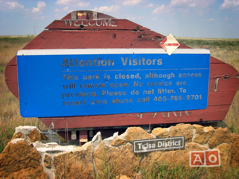
To begin the story of Optima Lake, I would like to give a little background.
I saw a story on News 9, which can be read here stating the park would be torn down instead of replacing a $1.5 Million guardrail that protects drivers crossing the dam. So we decided to hit the road, and document the park before it was lost forever.
Optima Lake is located in the panhandle of Oklahoma in Texas County on the Beaver River, approximately 4 1/2 miles northeast of Hardesty, and 20 miles east of Guymon. All public use areas around the lake are grown over and hardly accessible to vehicles, but remain open without any services like water or electricity. The lake was built in 1978 by the Army Corps of Engineers, but the water level never reached normal pool because of an extreme case of drought and evaporation in the area. This can be read about here.
There is approximately 3400 acres of land for public hunting and approximately 4300 acres of Federal Wildlife Refuge. According to the Army Corps of Engineers website, Optima Lake is also a prime area to view a variety of waterfowl, shorebirds and wading birds.
Even though there may not be any water in the lake, or any other visitors around, there is some amazing views of the valley below and the surrounding hills. The drive from Oklahoma City took 4.5 hours, but was well worth it. Next time, we’re bringing a tent!
Below is an article from the Oklahoman:
Parched Optima Lake loses last campground
By Dawn Marks
GUYMON — Not only is Optima Lake a body without water, it also is without a campground. Angler Point, the last campground in the often-dry Panhandle lake, did not open April 1 because of budget cuts and decreased usage, said Ray Kunka, who manages Optima and Fort Supply lakes for the U.S. Army Corps of Engineers. “We really have to set our priorities,” Kunka said. The corps is facing budget cuts, which will delay several large repair projects.
The 21-site campground had been open since 1981, when the parks were completed at Optima. In 1994, the corps closed its Optima office, an overnight campground and two day-use areas. Another site was never opened because the area had few visitors. Angler Point remained open because it did not have a shower/restroom that needed the frequent attention of corps employees. When the office closed, no employees remained.
The number of visitors at the lake has always been small. The lake, built for flood control, water supply and recreation, was completed in the late 1970s but never filled to capacity. The lake was designed to hold 5,300 acres of water but never had more than 1,200 acres, Kunka said. Many theories exist as to why the lake never filled, but the corps never did an official study, he said. Possible reasons include irrigation, lack of rain and evaporation. The water was just a few inches deep over the winter, Kunka said. “It’s basically dry,” he said.
Although the lake has never been more than 15 feet deep, the corps kept the campground open for hunters, who are its most frequent users. Volunteers worked to keep the site going after the office closed. Some acted as camp hosts while others did chores such as cleaning restrooms or mowing.
The site was usually open from April 1 to Oct. 1. It earned $2,400 in user fees last summer, down from $4,800 two years ago, Kunka said. Visitors paid by depositing money in a locked box. Kunka said the campground’s operating costs have always been much higher than its earnings. The site needed a water treatment plant and maintenance such as mowing. The treatment plant also required heat and electricity to prevent frozen pipes.
Kunka said he hopes a local group will operate the site and keep it public. He said Texas County commissioners have inquired. Commissioners were unavailable for comment Thursday. Guymon Mayor Jess Nelson said the closure probably won’t affect the city much economically, but it was considered an asset. Some groups worked to increase the number of walking trails and bird sanctuaries at Optima but made little progress, he said. Nelson said the area could still play a role in the area’s future if the corps allowed the Optima Water Authority to drill wells to provide water to surrounding communities.
Gallery Below


If you wish to support our current and future work, please consider making a donation or purchasing one of our many books. Any and all donations are appreciated.
Donate to our cause Check out our books!
[…] […]
90% of this is gone. The ranger station and maybe 5 picnic tables. No water, no people, just overgrown weeds! They did block the dam road. Sad waste of money and hardwork
As a young man I helped install the guardrail and before that drove a dumptruck while building the dam
is the dam still functional , could it still possibly fill up assuming there is a bout of rainy weather
On April 1 in about 1978 or 1979, the Guymon Daily Herald had an April Fool's Day edition that included a front page story about Lake Optima being filled when the fire department showed up to put out a grass fire started by a local fisherman throwing a cigarette overboard.
I foolishly loaned that copy of the paper to someone else and never saw it again.
What a cool place. And beautiful country out there. Looking at this place on sattelite imagery, it has a neat layout … what a shame.
JUST SAW IT! 8/18/2012 NOTHING LEFT BUT FOUNDATIONS, A VERY EXTENSIVE, ie, EXPENSIVE DAM AND COLLECTON TOWER. IN ITS CURRRENT STATE IT WOULD MAKE A GOOD ROAD RALLY COURSE OR MAYBE A GRAND AM FOR GO CARTS!
HAD TO GOOGLE TO FIND EXPLANATON OF WHAT HAPPENED.
ANOTHER WASTE OF TAXPAYERS BLOOD, SWEAT AND TEARS!!!!!!!!!!!!11
So are the gates open now? In case it rains?
Sorry…..Haven't visited this site in quite awhile…. Gates are "open" to prevent deterioration.. Should a water "event" ever actually occur, staff from Ft. Supply lake would have to travel to Optima Lake and lower the gates using a portable trailer- mounted electrical generator. They have assured me that the gates are still functional.
It's amazing to see the parallels between what occured @ Optima Lake and what is now currently happening @ Lake Meredith in Texas Panhandle. Deju Vu!!! Same situation!
Stopped by the damn today(1/4/12). I had always been curious driving by and just had to stop. It's obviously run down but it's easy to imagine it in the past. The area is very ghost townesque! I would have thought it was built much earlier.
Any idea how hard it's hunted(deer)?
Talk about sad. My grandparents Pete and Lili Craig used to take us to go camping and fishing there in the early 80's when we would visit them in Hardesty. We even lived there for a bit. Grandpa would catch a mess of crappie of the dam. I think my older sister even worked on the construction crew that built it in the 70's.
For info and house selections please http://www.sold2.us.
I went and took a look at it on July 4, 2011. Did not see a drop of water in it. And to think I was there the day it opened (July 1, 1978 or 1979 is my recollection) catching lots and lots of fish. Used to catch 100+ crappie a day off the big rocks off the dam. Sad, sad, sad.
Hi! I’ve been reading your site for some time now and finally got the bravery to go ahead and give you a shout out from New Caney Texas! Just wanted to say keep up the great job!
I worked in the office during summer break in college. So sad to see how it's been let go. Sad, sad, sad. But the land should be used for wildlife & hunters – hope the government doesn't screw it up.
I remember very well the construction of this ill conceived project and the fact that all the local landowners tried to tell the COE long before construction began that it would not work, the soils in the area will not hold water! The story about irrigation wells and such are just a flat out lie. The Beaver River has forever been known to retreat underground and resurface almost mystically and without cause or reason. Locals told the corps they would, at the very least, construct the dam to depth equal to the "red bed" if there were any chance at all of it ever holding water and even then the river would most like just "go around" the dam. Many locals watched the construction as entertainment and the subject was the laughing stock of most "coffee shop" discussions for the duration of the construction. The COE to this day refuses to admit the real reason this project failed, yet the natives to the area know full well the truth. This project should not only be considered misuse of funds, but criminal neglect. But then I guess egotistical behavior and stupidity aren't against the law!
I grew up in Hardesty having moved there from Keyes in '74. My dad was a heavy equipment operator with Guy James Construction, one of the contractors that was building Optima. I also began riding mountain bikes on the walking trails at Angler's point when they finally opened them to bicyclists. A group of guys, my wife, and me all would head out there on Saturdays or Sundays depending on when we could get together and ride the trails.
I moved from the area in 97 and only got back twice once to ride at Optima and the second time to ride at Palo Duro Canyon. Since then I have only been as far as Liberal one time. So, when I see these pictures it pisses me off that the people in the area have not stepped up taken care of this place despite the fact that the rains stopped and the Government failed at it's job once again.
man i grew up in this area and i used to go there as a kid. some of my best memories are from visiting there with my family and i was hoping to someday take my kids but i guess thats no longer possible. its very sad that its no longer as beautiful as i remember.
I just read in the Guymon Daily Herald that the Corps of Engineers should be finished demolition of the Recreation Areas by August 15th and removal of the gates by September 15th (THAT CAN'T BE RIGHT! – Surely they don't mean the dam gates). What the….?? Only by checking the COE website did I find that the Corps announced their decision on June 15th and had a meeting here in Guymon on June 29th. I was also under the impression that the embankment roadway was to formally be passed to local county control and maintenance. With all the support that was shown by our local politicians, what happened? I was assured by the COE at the winter meeting that they would make a better effort to keep the public informed. Boy, do I feel hosed……
Note to Brent: Not all of us old "dinosaurs" are on Facebook, I'll try to get in touch with you by other means
It's a creepy place. A sad example of greed and waste. Return the land to the former owners.
The former owners are dead now. Much of that land belonged to Ida Mae Jones who recieved a healthy compensation for it including but not limited to a brand new home and more land. I grew up in Hardesty, my dad was employed with Guy James Construction, one of the contractors that built Optima.
I grew up in Hardesty and on the last day of school in the late 70's we had about a ten inch rain in Texas county. Some kids couldn't even get to their homes when we returned from Amarillo. We were all excited because we thought this would fill up the lake, then learned that the gates were opened up because of a couple construction vehicles left near the water. Bet they wish they would have just left them there! I know I do.
I remember that last big rain that we got. Sadly, the reason the gates were open is because of a contaminate spillage at one of the feed lots up stream on the Beaver river (or the Cimmaron) which ever that is that you cross just as you come up the hill into town.
So is this Doug?
A work friend and I were sent out near that area on a job. We looked at the (current) State Atlas and saw an actual (blue) lake represented with a dam in place. We thought, "Go fishing."
We told the folks at the job that we were planning after the job to go to Lake Optima and go "fish off the dam". One guy said he wanted to go because always wanted to see a guy cast a line three-quarters of a mile!
Hey Ranger B,
What happened to the guy here lately that wanted to use the Optima area for Hunting Dog training? He claimed he could bring in tons of Revenue for the local areas.
I was outof town when they had the hooker city meeting over that. Never heard what happened one way or the other.
It is very sad to watch all thise tax dollars gone to waste. Corpof Engineers needs to turn it back to land owners if they won't allow anyone to use it to bring in revenue to the local communities. Oh, Wait! That is what is was designed to do.
Just thought I’d clarify a few things. I was a Park Ranger @ Optima Lake from 1979 through 1994. Number 1: There never was a “State Park” @ Optima Lake. The State of Oklahoma declined this option in the planning stages (most likely due to cost). All of the recreational facilities were managed by the Corps Of Engineers. Number 2: The Coldwater Creek “arm” of the “lake” is a National Wildlife Refuge administered by the U.S. Fish & Wildlife Service while the North Canadian (locally called the Beaver) River “arm” is run by the Oklahoma Department of Wildlife Conservation. Number 3: the dam itself is 3 1/2 miles long, and actually at it’s highest level (in the mid-80’s) had a max depth of about 10 feet of water! The damage to the facilities is a combination of vandalism, lack of any maintenance for about 15 years and slow destruction and removal by the Corps. Number 4: There was no tornado damage. There was some range fire damage (particularly to the infamous guardrail) but this was relatively minor in the recreation areas. I’d be glad to answer any questions I can regarding this site. Having spent 15 years of my life working there, count me as one of the most disappointed in it’s outcome!
Ranger B,
i, too, am not excited about the outcome of the lake project. However, you have to admit that the area is a great place and a great asset to the panhandle. We are currently fighting a good fight with the politicians that are threatening to de-authorize the project, tear everything down, and breach the dam. The are also wanting to sell it to the highest bidder! I would like your input on a few things if you would!
Anyone else interested in helping us preserve this land for public use, please go to the following facebook link: http://www.facebook.com/?ref=home#!/pages/Hardest…
You can find good information of what's happening and you can help us Keep Public Lands in Public hands!"
You tell them Ranger B!
Hey B! I know you. My dad is Everett. You used to kid me about using my 79 AMC Spirit for parts for your Eagle. Not to sidetrack the issue but I was wondering how you had been.
Kelly
Great pictures!
I'm always amazed how people comment about the run down facilities, obvious lack of water and complete project failure of the U.S. Army Corp of Engineers. Why not think of the family's that had their land forcibly taken through innment domain action by the U.S. Government. Then watched for the next 43 years (1966 – 2009). I would lay odds the land supported more more wild life on the ranch land before the U.S. Government got near the land. Texas County, The U.S. Corp of Engineers and the State should just give the land back to the original land owners with a huge apology!
I grew up in this area and spent quite a bit of my early years camping at this place. I loved it. Then, while in high school, it was a popular place for my friends and I to party and camp on weekends because there was really no law enforcement patrolling the lake area.
It's really sad to see it in the state that it's in now.
Its still a very beautiful place:)
Now look at it though. Too many kids had the same idea it appears and destroyed the picnic area. That damage is not natural but teen inspired.
well I was close actually it is ten miles east of Hooker, Oklahoma on hiway 64.
http://maps.google.com/maps?sourceid=navclient&am…
I went through this area in 1979 on a trip to Colorado. There were campsites, picnic areas, restrooms and playgrounds. It was all brand new, but there was no water in the lake. I walked the whole Hardesty area on a hot August afternoon with a cold beer in my hand. I was 18 at the time and left my camera in the car. Dummy.
I also stopped here with my family in about 1988. The roads were starting to show grass in the cracks then. There were a group of RV campers there and one of the campers there told me they came to this site regularly because it was cheap and private. The water in the basin was less than your pics show now.
I have driven by since but have never stopped.
Thanks for the pics.
during this year it has rained alot and the lake is way more filled then how it looks in all those pictures (they cut out alot out of the lake even in those pics[no afince ,or however you spell that word])i live in hardesty and the lake is way more beatiful then it looks like in those pics.:)
Oh and by the way you were just thirty miles away from the old Baker school…. You would have loved checking it out. Its north about twenty miles then west for about ten miles. The school sytem was abandoned back in the sixties.
Oh man! I wish we would have known that! Send me a link to the google map of the school and we can always make another trip!
You definitely need to go to Baker and see the Eureka High School. Big huge school in a tiny town just sitting vacant. Its eerie!
the part of the story that has not been told recently is that this hoped for lake had been authorized to be built for forty years before it actually got built.
Oh guys! Amazing pics! what do you thing whould make thos shelter structures all crumble in the same direction? wind? any thoughts?
My thought was strong winds. There was an area that was surrounded by trees and they were still intact. Also, on the backside of the dam at Anglers Point, the ground is so far below the dam, that the winds wouldn't be to strong there either and they were mostly standing. Possibly a tornado, I couldn't find anything in the archives about it.
Most likely due to the fact they were constructed by the same minds that built the dam! Weather deterioration and poor construction. The elements out there are very unforgiving with extreme temp fluctuations, strong winds, dry heat, all really takes its toll on poorly constructed facilities very quickly.
I was wondering the same thing. You think if it was a tornado things would be more strewn about instead of, er, tipped.
Wildfires burnt the support posts.
I have to say that looks like destruction of the teen persuasion.
Nearly all the buildings, in all the picnic areas were structurally ROCK SOLID, (6 months before their demolition) although some were vandalized and all were faded and overgrown with weeds. I couldnt help but have the opinion that some unscrupulous person hoped to get a demolition contract when a certain congressman complained mightily about stimulus dollars being spent to fix the guard rails bordering the highway across the top of the dam (which needed to be fixed as the road connects different points of the county).
Then a huge number of the picnic structures had their supports removed in an identical way (accidentally on purpose) coincidental to the time when it was decided that no stimulus dollars would be spent at the project EXCEPT for demolition of dangerous structures which would create a liability for the state. Of course after that, 6 months later, major damage appeared to dozens of these and some felt demolishing them was now an emergency (first they said nobody visits the lake, then suddenly scores of people were going to go get killed or injured by entering these dangerous buildings or walls would suddenly collapse on children…oh my) 🙁
This place looks pretty dam cool.
hardy har…. good one….
Awesome! I've heard about this place for some time now, but never wanted to drive all the way out there. Thanks for the pics!So is that an actual dam in pic #24 or what? I cant tell… Oh and I spotted your car again, pic #31, its trying to hide haha.